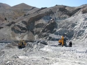
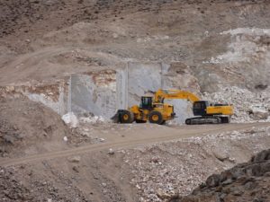
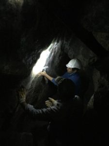
Iron ore deposits
In the iron ore deposits of Hadid Gostar Sirjan Company, it is active in the exploration, extraction and processing of the following categories:
 Hadid 1 and 4 are located in Khorasan Razavi , south of Sangan town and south of Khaf area.
Geology:
The area in which iron ore is made up of alluvial deposits and Placer in the flat plain is related to the era of the Quaternary, which is affected by the loss of the main mass of iron ore in the Kuh Taleb or Zangi Mountain area and the Baghak minor intrusire body and red hills. And as a result, at the bottom of the plain (west, southwest), this mass of iron ore has created a relatively large plain in the form of Deltas (up to several kilometers)
The main mass of iron ore is now the site of the Sangan mine, which is currently in the stage of equipping. The main lithology of this mass is often Magnetite with Andesite.
The origin of magnetite in these Placers is the Sangan iron ore mining site which is geologically stored in the iron skarn reserve and is located in the north, the type of placer in this region is of the continental and alluvial deposit types.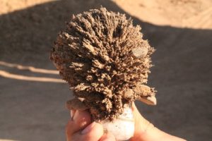 The mine is located about 140 km north-east of Shiraz and 15 km north-east of Safashahr (Dehbid).
Geology:
The study area is located in Sanandaj-Sirjan structural zone. Rock type include dolomite, slate, rhyolite and meta-alkaline. Their general trend is from northwest to south east and a general slope to the southwest. Iron chemistry has occurred in a carbonate zone, sometimes with Rhyolite .The iron is expanded in a specific stratigraphic horizon in the form of a lens and patch that is detectable.
- The mine is located about 12 km from the Baghat village, located in Hajiabad, Hormozgan province. Economic advantages of the Mine is location witch situted to the asphalt road of Bandar Abbas-Sirjan. The distance from Bandar Abbas is about 214 kilometers.
Geology:
Based on the structural division of Stocklin (1968) in the Sanandaj-Sirjan zone. Geological surveys were carried out at a scale of 1: 1000 in a range of about 800 hectares with center of iron masses. The rock units included in this range include Cambrian schists, Slit, with Cambrian Middle Cambrian The upper part is with Middle Cambrian-Upper Cambrian, dolomiti (Pd) with Cambrian-Ordovician age, Marbella limestone (Pm) with Cambrian-Ordovician quartzite (Pqtz) age with Cambrian-Ordovician age, Pmg granite Cambrian-Ordovician age, Cambrian-Ordovician-Pmd metadata (Pldm), Cambrian-Ordovician age, Quartz vein, Dolomite-limestone marble (Pldm).
 The study area is about 17 km south of Rafsanjan city in Kerman province.
Geology:
The area under discussion is located on the margin of the Gondwanasa plate in the south and the Eurasia plate in the north, which includes the Central Iranian plate and the Afghan block. The major part of the region’s rocks is Eocene and the upper of the Oligocene. This complex is often influenced by deep granitoid masses, mid-Eocene to Oligocene, and semi-deep masses at the time of the middle Miocene (Dimitriff, 1973)
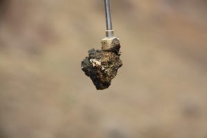
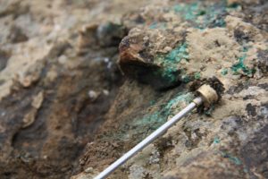
Chromite
Dare to say that among all minerals, Chromits has better conditions in comparison of other items to export and exchange for country due to its higher price. Hadid Gostar Sirjan with knowledge of this matter in recent years through its subsidiary Talashgaran Parseh company has proceed mineral studies in Khorasan province. In this regards this company by choosing about 100 km2 of Sabzevar Ophiolite belt which is one of the most full potential in the country, has done vast exploration and exploition studies.
Geology:
 This collection is part of the ophiolite belt around eastern Iran. Two chromite deposit types are visible in these areas:
- Lens-shaped and irregular deposits: most forms of chromite deposits are irregular and are mostly lenses with single or multiple lenses. In most of the focal points of the mineral, the mineral initially has seen as an effect on the stones in the perpendicular stones, and then the concentration of mineral in the direction of the north-east-southwest as well as the perpendicular to it in depth.
- Resources in the form of disseminated grains in the peridotite stone: another form of chromite deposits that is widely seen in the region is the presence of scattered chromite grains in the serpentinized peridotite rocks, in which the chromite appears in black beans shape in the Light green texture of peridotite Rocks is distributed and macroscopically detected in manual samples.
Decorative Stones
The Hadid Gostar Mining Department of Sirjan, after systematic exploration and extensive adventures in Khorasan Razavi province, has been able to identify porcelain marble streams and subsequently obtained exploratory studies on qualitative and detailed scale and obtained exploitation license from the Mining Industry Organization and trade in Razavi Khorasan province. Mining in this mine has a calcium carbonate content of 99% purity, which is referred to as marble in the market, and earth scientist has named the onyx on it. Based on the results of the exploration and extraction excavations that have been revealed in the mine, the colors, elegance, unique luster, proper cropping, the use of small pieces in the precious and semi-precious and on the other hand the presence of customers Domestic and foreign, has led to the introduction of a precious mineral deposit with a precious mineral. The company intends to launch a large research study on the processing of semi-precious stones at the level of foreign markets, followed by marketing, sales and valuation, with the aim of creating and developing the stone-making industry in the country.
In the Onyx Reservoir, Hadid Gostar sirijan Co. is engaged in exploration, extraction and processing in the form of Jodi quarries, Kalateh and Parseh.
Geology:
 The above mineral complex is located in the mountains of a Hezar Masjed in northeast of Mashhad. The geological structure in this range includes sedimentary facies (limestone).
Geologically, the abovementioned organization can be considered the continuation of Mozdooran organizations, in which case the limestone age of the region is attributed to the Jurassic period. In addition, the area is relatively active in terms of tectonics and fractures with the northwest of the south-east trend are observed in the dark limestone in the region. Therefore, the mineral which is a marble type of white to milk vegetation is due to the penetration of solutions containing calcium carbonate enriched in fractures. These solutions, while rising, containing very fine particles of iron oxides such as hematite and limonite. They have been replaced by orange due to high pressure and heat.
Copper
In the copper section , Hadid Gostar Sirjan Company, operates in the following sets of exploration, extraction and processing:
this area is located in Markazi province and in the south-east of Paredak.
Geology:
Based on the tectonic-sedimentary environment of the Iran, mineral deposits of copper located in the middle part of the Urumieh-Dokhtar zone (Stocklin, 1968), which includes the following four units:
- Early Eocene: Periodic pyroclastic rocks of volcanic-violet lava (E1pr), which are formed from tuff and slice and dyty-purple lava. These rocks turn upside down to white and purple acid tuffs
- Middle Eocene: Endodontic: volcanic-rhytolite (E1pr) lava, discontinuous and sequential, of tuff and rhythetic yellow tuffite (Erltt2), which have been infiltrated by several diabetic dikes; – the sequence of pyroxene andesite rocks to lava with flow and The semi-pillow structure has been continued and the Ean2 unit is continuously and continuously sequenced from conglomerate, sandstone and lichen as well as an ecosystem (Ec3 unit), a sequence of tuff and white acidic sections (unit Ecl3), interlayer-rhyolitic ridges, Eigenbright and Tof Units Erlt3 – Indestructible Carbonate And Andesitic Stones (Elv3 Unit) Slope On Rivlite Unit
- Final Eocene: Latitude-Andesite lobes, Pebbles, Tuffs, Tuffs and Ignimrites
- Oligomycesen: Nomolytic limestone and marls of Qom Formation (OMlm unit) – Upper Red Formation with Myoplucan Age with Alternate Gypsum Marl, Sandstone and Red Conglomerate on Qom-Zaviah Formation Alluvial Sediments and Qt and Qal Formations River Terraces
Haji Bolaghi copper ore deposit is located in north east of central province and north east of Saveh, southeast of Mamuniyeh. The distance from Tehran is about 104 kilometers. The above mine is located 3 km southwest of Haji Bolaghi village.
Geology:
- Andesite (Ean): This unit is Recognizable for its dark gray to grainy gray and large plagioclase crystals. Andesite is the widest and, at the same time, the oldest rock unit in the mine.
- Agagemore (Eag)
- Crystal Tuff (Et): The Eocene Age is the largest outcrop in the Andesite Region. Tuft crystal has rhythmic layering and has been heavily silica in places where the copper mineralization host is located, so that this unit can also be called silicon tuff.
- Silicone coating (Esc)
- Andesite cutting (Eban)
- Dyck Andesite (Eand)
This mine is part of the Miankouh copper company, a subsidiary company of Hadid Gostar Sirjan Mining Group. The Miankou copper mine is located in the northeast of Khomein and in the southwest of the Mahallat and on the old road to Khomein, near the village of Shoorab.
Geology:
The main constituent parts of this range comprise shales and slides of the Shemshak organization with Jurassic age and relatively less than limestone, sandstone and conglomerate with the middle Cretaceous age covered by alluvial deposits and quaternary deposits.
 This area is located in Markazi province and in the south-east of Zavieh city.
Geology:
The outcrops in the exploratory area mainly consist of Eocene sedimentary volcanic deposits, as well as oligocene-Miocene intrusive masses. Intrusive masses and dikes after the Eocene (Oligo-Miocene) cut Eocene deposits. Also part of the northern areas is quaternary deposits.
The following units are divided into new to the old.
- Units of volcanic and igneous rocks of Eocene
Eocene volcanic rocks unit (Ev Unit) – Tuff to Heart to Gray (Et) – Agglomerative unit (Eag) – Olivine basaltic and Andalie basaltic unit (Emb) – Basalt unit to Andesite sppilite (Eb) – Andesite unit Eat) _ Unity Unit (Ei) _ Unit Andesite Basalt (Eab) - Intrusive bodies of the region
Gabardiature masses (Gd) – Quartz diorite-granodiorite dikes (Dk) – Granite mass (Gr) - Quaternary (Qal, Qt)
- Units of volcanic and igneous rocks of Eocene
This area is one of the mines of the Miankouh copper company from the subsidiaries of Hadid Gostar Sirjan Mining Group. The Laki Range is located in the southwest of Khomein and on the Khomein-Aligudarz Road.
Geology:
In this area, three major rocky units can be distinguished:
shale classes – Late Triassic sandstone – Lower Jurassic (TR2-J1):
This collection is divided into two (parts). Age divisions of these two sections are not the subject of the project and only to determine their scope.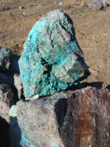
- Shale Classes – Late Triassic Shiite – Underneath Jurassic (TR2-Jsh)
- Late Triassic sandstone floors – Lower Jurassic (TR2-J1sd)
Cretaceous limestone classes
At the end of the southeast, there is an area near the village of limestone with a morphology of the bedrock which is widespread and with no geometry, almost horizontal, on the Chilean-Chilean sections referred to above (TR2-J1sh). This unit of stone is the folds of Cretaceous times and is characterized by limestone lithology and late Cretaceous fossils. These limestone layers are of medium to solid type and do not show friction and stiffness.
Quaternary sediments
In a general assessment, the study area is considered to be naked and uncovered, which has only been developed in small sections of tellurium and localized deposits (diluvium), but more or less is a geologic substrate that is clear and measurable. . In the Southwest and West sections, the agricultural sectors are covered and the fields and gardens of the villages are built that are not visible through study coverage. But at all times, the geological substrate is from the species of slivers and Jurassic shales.
These ranges are part of the mines of Talashgaran Parseh Zarrin Gavashir Co. from the subsidiaries of Hadid Gostar Sirjan Mining Group. The depuple Ranges of Zarrin Gavashir gamers are located in the southern part of Jabal Barz and in the east of Jiroft city.
Thermal coal
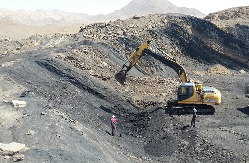
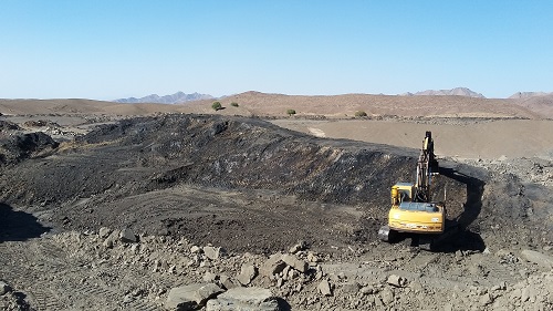
In the thermal coal sector, the Hadid Mining Group of Gosarjjan, in the form of Kowsar Zarrin Azar Company, is engaged in the exploration, extraction, processing and, finally, commercialization of this mineral in the Booj coal mine.
Kowsar Zarrin Azar Coal Company
The Group is the owner of the exploitation of Booj coal mine, operating activities in the mine began after extensive exploration activities in the area of 25 square kilometers of the mine and are currently being opened outdoors. In addition to exploration and extraction activities, processing and testing, underground mining projects, design of the coal mill and the International Trade of the product, especially the export to Turkey, are being carried out by experts of the company , domestic and foreign consultants.
Development plan:
This holding Consider to conclude with the continuation of exploration and expansion of extraction and establish coal washing unit, with an annual capacity of 300,000 tons at the mine site and according to the latest technologies of the world and attracting foreign partnerships, the construction and export product with a higher quality and tonnage More produces.
Geology:
In the period covered by the periodicity, there is a quasi-quartz sandstone and green and gray to brown shale limestone, with a wide range of coal, which is the same as the jade constructor. The lower Hijdak Formation (Badamo) and above it are not within the scope of the Bojan mine. Even parts of the lower and upper parts of the Hijdak Formation are not located in the Bojan Mineral Block.